About
7.5.2 Geostationary Satellites
7.5.2.1 Introduction
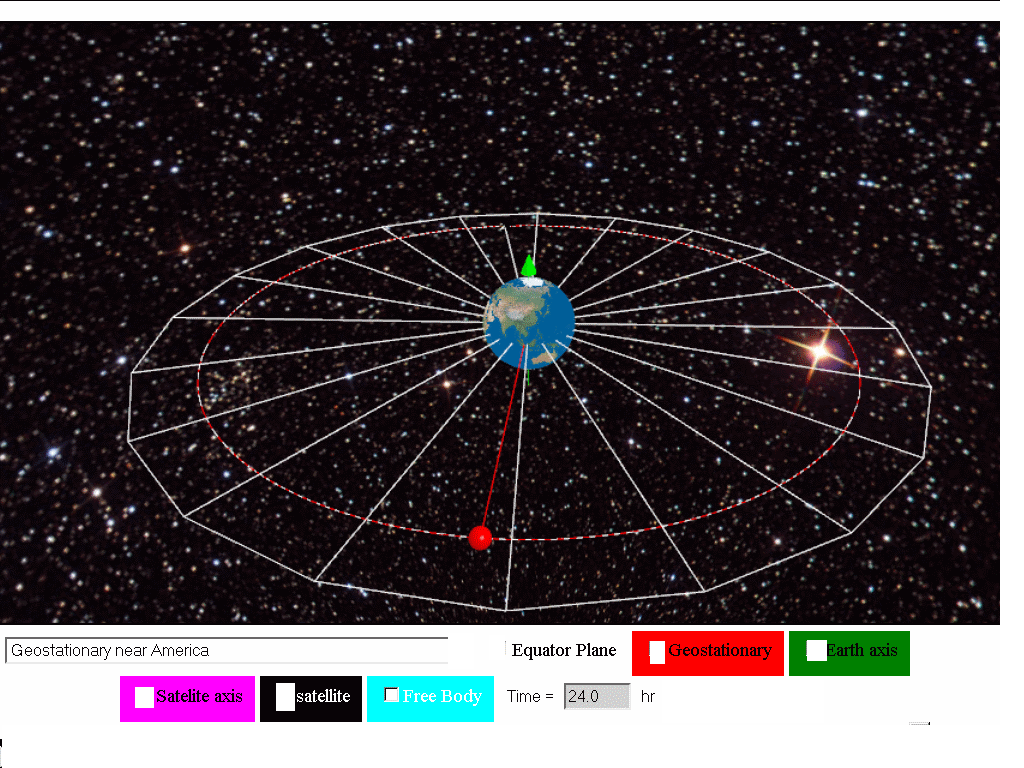
A geostationary (Earth) satellite is a satellite that rotates around Earth in a certain orbit such that it is always positioned above the same point on the Earth’s surface. Hence from the point of view of an observer standing at that point, the geostationary satellite appears to be always ‘stationary’ above him/her (but actually, both observer and satellite are rotating at the same angular speed). In order for a satellite to be moving in such a geostationary orbit, there are certain conditions to meet:
7.5.2.2 Characteristics of Geostationary satellites
- placed vertically above the equator
- same directional sense as the rotation of the Earth (determine through axis of rotation)
- same orbital period of Planet, in our case, Earth, thus the orbital period of approximately 24 hrs
7.5.2.3 Determination of height above Earth surface for geostationary orbit radius.
Analyzing the free body diagram of a satellite traveling in a geostationary orbit, we know the force on the satellite is assumed to be only due to Earth's gravitational pull. The period is approximately 24 hours = (24)(60)(60) = 86400 s
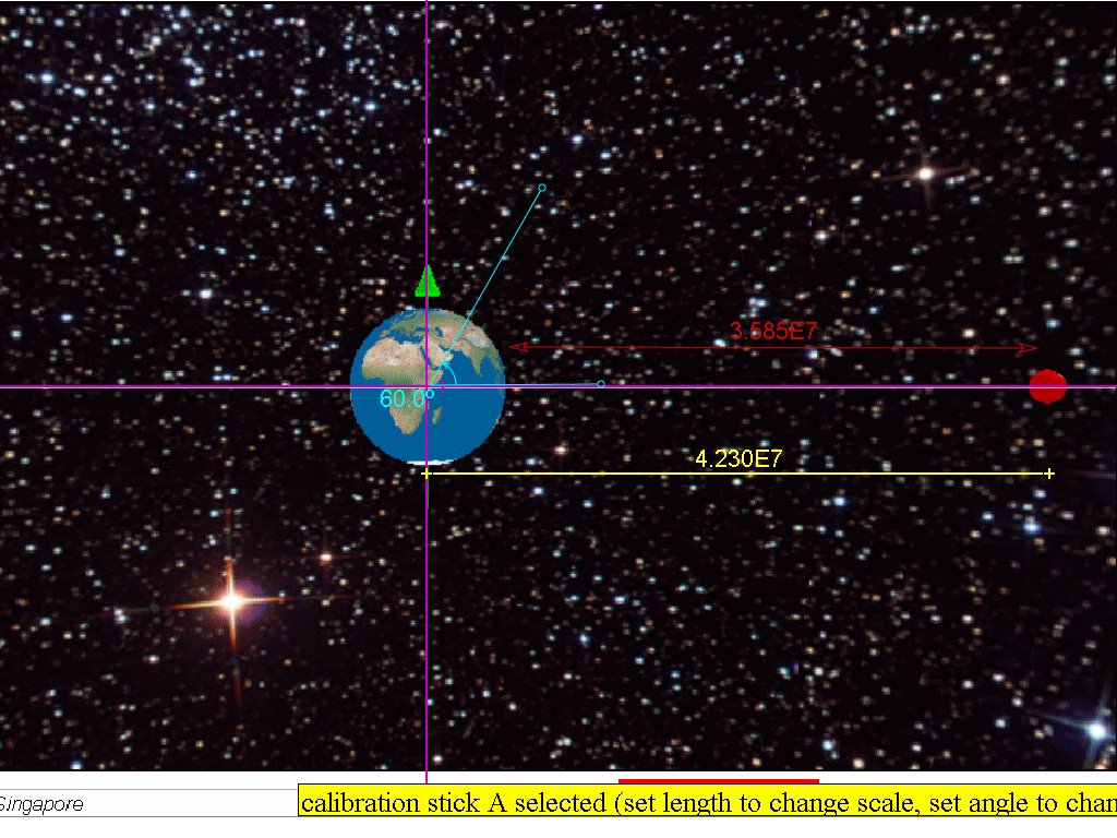
r = 4.23x10⁷ m which is r = 3.59x10⁷ + 6.37x10⁶ m, where radius of Earth = 6.37x10⁶ m.
which is why Earth's geostationary satellites must be placed in an orbit at a fixed distance (around 35 700 km) from the Earth’s surface, in order to rotate with the same period as Earth.
7.5.2.4 Advantages of geostationary satellites:
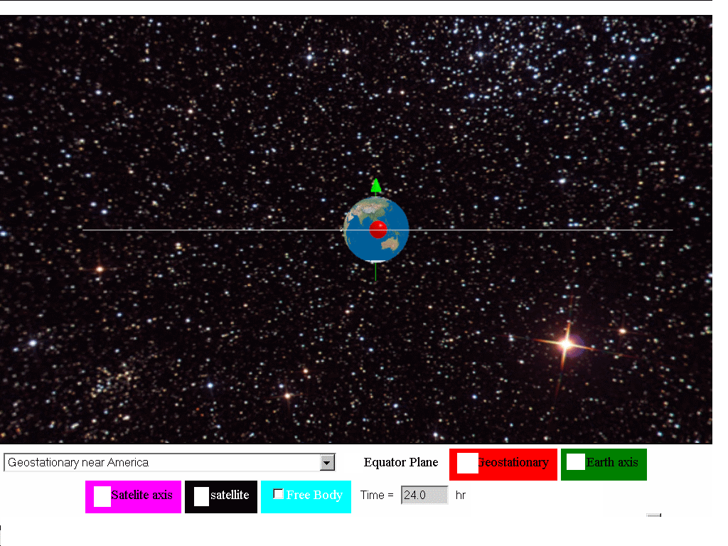
- A geostationary satellite is ideal for telecommunication purposes since it remains ‘stationary’ above the same spot on the Earth’s surface at all times. The distance between the satellite and the transmitting station on Earth is kept relatively constant and a clear line of ‘vision’ between the transmitter and the receiver allows continuous and uninterrupted signal transmission.
- Since it is always at the same relative position above the Earth’s surface, there is no need to keep adjusting the direction of the satellite dish to receive signals from the geostationary satellite.
- As geostationary satellites are positioned at a high altitude (a distance of 3.57 × 10⁷ m away from the surface of the Earth), it can view a large section of the Earth and scan the same area frequently. Hence, they are ideal for meteorological applications and remote imaging.
7.5.2.5 Disadvantages of geostationary satellites:
- As geostationary satellites are positioned at such a high altitude, the resolution of the images may not be as good as those captured by the lower orbiting satellites (example shown is polar satellites in orbits at r=1.133Rearth with orbital period of 2 hours).
- Because of its high altitude, there may be a delay in the reception of the signals resulting in a lag time for live international broadcasts or video conferences.
 The transmitting
stations in countries positioned at latitudes higher than 60 degrees may
not be able to receive strong signals from geostationary satellites, as
the signals would have to pass through a large amount of atmosphere.
This is true for countries beyond the 60 degrees latitude ‘belt’, both
on north and south sides.
7.5.2.5.1 What are polar orbits?
Besides geostationary satellites which are placed at a large distance from Earth, there are other types of satellite which orbit at lower altitudes from Earth, like the polar orbit satellites as shown below.
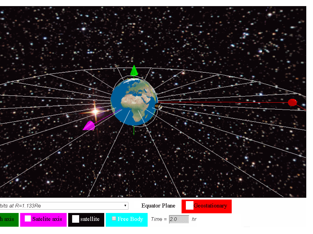
Satellites in polar orbits rotate around the Earth over the poles, in a constant plane perpendicular to the equator. Polar satellites have much lower altitudes (about 850km or R=1.133Rearth with orbital period of 2 hour) which serve to provide more detailed information about the weather and cloud formation. However satellites in this type of orbit can view only a narrow strip of Earth's surface on each passover orbit. Strips of images must be "stitched together," to produce a larger view.
7.5.2.6 Would a geostationary satellite that orbit around planet Mars be at the same distance r = 4.23x10⁷ m ? Why?
referring the data from https://en.wikipedia.org/wiki/Mars, MMars = 6.4185×10²³ kg, Sidereal rotation period T =1.025957 day.
r =2.04x10⁷ m,
thus it is different due to the different planet mass and rotation period.
7.5.2.7 Example (J2000/1/8)
Which quantity is not necessarily the same for satellites that are in geostationary orbits around the Earth?A angular velocity C kinetic energy
B centripetal acceleration D orbital period
Answer C: Kinetic energy is dependent on the satellite's mass and velocity. Hence different satellites of different masses may have different kinetic energies.
7.5.2.8 Example
A spacecraft was launched from Earth into a circular orbit around Earth that was maintained at an almost constant height of 189 km from the Earth's surface. Assume the gravitational field strength in this orbit is 9.4 N kg-1, and the radius of the Earth is 6 370 km.a) Calculate the speed of the spacecraft in this orbit.
b) Find the time to complete one orbit.
c) Comment whether this spacecraft is in a geostationary orbit
7.5.2.8.1 Answer:
Since the condition for circular motion is assumed to be true, we can use the circular motion equation while also assuming only the Earth's gravitational force acts on spacecraft.rearranging to get
substituting
7.85x10³ m/s = v
b) Since
and
substituting
T = 5249 = 5.25x10³ s
c) Since the spacecraft does not satisfy one of the condition (ie. T not 24 hours), it is safe to conclude that the spacecraft cannot be geostationary.
Repeated here are the characteristics of geostationary orbits are:
- placed vertically above the equator
- same direction sense as the rotation of the Earth (determine through axis of rotation)
- same orbital period of Planet, in our case, Earth orbital period of approximately 24 hrs
7.5.2.9 Model
7.5.2.9.1 Geostationary Satellite around Earth Model
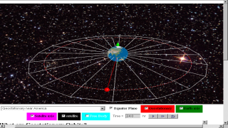
This Geostationary Satellite around Earth Model is a simple angular velocity model that uses the Java3D implementation for realistic visualization of satellite objects in geostationary orbits at three different locations namely (near Singapore, near Africa and America) . Students can explore the meaning of geostationary orbits, cases of non-geostationary orbits and even non-gravity physics orbit .
7.5.2.9.2 Geostationary Satellites
The term Geo-stationary implies a satellite fixed about a position above the earth. This is possible because such satellites have the same period as the Earth’s rotation (T = 24 hours) 2 same rotational sense as the earth's rotation spin 3 is a location directly above the equator in other words the plane of rotation of the satellite must be in the plane of the Equator. Therefore, it appears stationary.
7.5.2.9.3 Application
Example of geostationary satellites are GMS1, GEOS, METEOSAT etc. Most of these satellites are used for commercial and military purposes
7.5.2.9.4 Main Simulation View
The simulation has a Earth and a Satellite object Menu Drop Down Allows for selecting what motion of Satellite is simulated.
- Geostationary near Singapore
- Geostationary near Africa
- Geostationary near America
- Non-geostationary due to direction
- circular motion r=3*Re, T =7.30 hr
- circular motion r=10.5*Re, T = 48 hr
- Non-Geostationary generally
- Unlikely Orbits
7.5.2.9.5 Check boxes
- Show:equator Plane, for visualizing the Earth's rotating equator plane
- Geo stationary, for visualizing a geostationary object (RED) for comparative observation with the other modes.
- Show text: 35 700 km fixed position of object relative to planet earth.
- Axes earth: show spin axes of the rotation of earth in GREEN
- Axes satellite: show spin axes of the rotation of satellite in MAGENTA
- Force: pair of action reaction force of equal magnitude, opposite direction and on different bodies. (Newton's 3rd Law)
7.5.2.9.6 Buttons
- Play
- Step Forward
- Reset
Translations
| Code | Language | Translator | Run | |
|---|---|---|---|---|
 |
||||
Credits

 lookang; Francisco Esquembre
🛰️
Briefing Document: 🛰️Geostationary Satellites & Interactive Simulation
1. Overview
This document summarizes a resource from the Open Educational Resources / Open Source Physics @ Singapore website focusing on geostationary satellites. It includes an interactive 3D WebGL JavaScript HTML5 applet simulation model for educational purposes. The resource aims to explain the characteristics, advantages, and disadvantages of geostationary satellites, comparing them to polar-orbit satellites, and it also provides examples and calculation exercises. A core component is the interactive simulation, which allows users to visualize and manipulate satellite orbits.
2. Key Concepts & Themes
- Geostationary Satellites: The central theme is understanding geostationary satellites, which are defined as satellites that maintain a fixed position above a specific point on Earth.
- "A geostationary (Earth) satellite is a satellite that rotates around Earth in a certain orbit such that it is always positioned above the same point on the Earth’s surface."
- This "stationary" appearance is achieved by matching the satellite's orbital period with the Earth's rotation period.
- Characteristics of Geostationary Orbits: Three key characteristics are required for a geostationary orbit:
- Positioned vertically above the equator.
- Rotating in the same direction as Earth's rotation.
- Having an orbital period of approximately 24 hours.
- Orbital Mechanics: The document explains the physics behind geostationary orbits, showing how gravitational force provides centripetal force, leading to:
- Calculations to determine the precise altitude (approximately 35,700 km) necessary for geostationary orbit.
- The relationship between gravitational force, orbital radius, and orbital period are highlighted.
- The equation derived is: G m M / r^2 = m r ω^2 = m r (2π / T)^2
- Advantages of Geostationary Satellites: The advantages are predominantly linked to communication and observation:
- Telecommunications: Constant position ensures uninterrupted signal transmission. "The distance between the satellite and the transmitting station on Earth is kept relatively constant..."
- Simplified Tracking: No need to adjust satellite dish direction. "...there is no need to keep adjusting the direction of the satellite dish..."
- Wide Coverage: High altitude enables large area scanning. "...it can view a large section of the Earth and scan the same area frequently."
- Disadvantages of Geostationary Satellites: The resource also notes drawbacks:
- Resolution: High altitude results in lower image resolution. "...the resolution of the images may not be as good as those captured by the lower orbiting satellites"
- Signal Delay: There can be a lag time due to distance. "...there may be a delay in the reception of the signals resulting in a lag time..."
- Limited Coverage at High Latitudes: Areas beyond 60 degrees latitude may struggle to receive strong signals.
- Comparison with Polar Orbits: The resource contrasts geostationary satellites with polar orbit satellites, which:
- Orbit at much lower altitudes (~850 km)
- Pass over the poles.
- Provide more detailed, but smaller-area images.
- Have a shorter orbital period of approximately 2 hours.
- Geostationary Orbits Around Other Planets: The resource notes that the geostationary orbit altitude for Mars differs significantly from Earth's due to different mass and rotational period. "...it is different due to the different planet mass and rotation period."
- Interactive Simulation: A key educational tool.
- Offers various simulation options: geostationary orbits near Singapore, Africa, and America; non-geostationary orbits due to direction; circular motion orbits with different radii and periods.
- Visualizes the equator plane, geostationary objects, satellite axes, and forces.
- Provides controls for play, step-forward, and reset.
3. Important Facts & Calculations
- Geostationary Orbit Radius: The document calculates the geostationary orbit radius to be approximately 4.23 x 10^7 meters from the center of Earth, which translates to approximately 35,700 km from the Earth's surface.
- Earth Radius: 6.37 x 10^6 meters.
- Earth Rotational Period: Approximately 24 hours, or 86,400 seconds.
- Geostationary Mars Orbit Radius: Calculated as approximately 2.04 x 10^7 meters
- Example Calculation: A spacecraft in orbit at 189km altitude above earth, was used to calculate the speed ( 7.85x10^3 m/s) and orbital period (5.25x10^3 s). This confirmed that it is NOT geostationary.
4. Key Quotes
- "A geostationary (Earth) satellite is a satellite that rotates around Earth in a certain orbit such that it is always positioned above the same point on the Earth’s surface."
- "The distance between the satellite and the transmitting station on Earth is kept relatively constant and a clear line of ‘vision’ between the transmitter and the receiver allows continuous and uninterrupted signal transmission."
- "Because of its high altitude, there may be a delay in the reception of the signals resulting in a lag time for live international broadcasts or video conferences."
- "Satellites in polar orbits rotate around the Earth over the poles, in a constant plane perpendicular to the equator."
- "The term Geo-stationary implies a satellite fixed about a position above the earth. This is possible because such satellites have the same period as the Earth’s rotation (T = 24 hours) 2 same rotational sense as the earth's rotation spin 3 is a location directly above the equator in other words the plane of rotation of the satellite must be in the plane of the Equator."
5. Educational Application
- The interactive simulation is a tool for visualizing the abstract concept of satellite orbits.
- The resource is designed for use in junior college level physics courses, indicated by the tags "Junior College" and "Gravity."
- The inclusion of mathematical calculations allows students to understand the physics behind geostationary orbits.
- The presence of examples and exercises encourage active learning and promote conceptual understanding.
6. Interactive Features
- The simulation allows users to explore the various characteristics of geostationary and non-geostationary orbits.
- Checkboxes to visualize the equator plane, geostationary object, axes of rotation, and forces.
- Buttons for simulation control (play, step forward, reset).
7. Related Resources
The document also includes a long list of additional educational resources developed by the same team using WebEJS, covering a wide range of topics in physics, math, and other areas, suggesting a broad commitment to interactive educational tools.
8. Conclusion
This resource offers a detailed, interactive, and mathematically grounded explanation of geostationary satellites and their orbital mechanics. The combination of textual explanations, calculations, and interactive simulations makes it a valuable educational tool for students learning about orbital physics. It also includes examples, application and calculation exercises, making it suitable for use in junior college or high school settings. The comparisons with polar satellites and geostationary orbits of Mars provide a broader view of the application of these physical concepts.
Geostationary Satellites Study Guide
Quiz
Instructions: Answer each question in 2-3 sentences.
- What is the defining characteristic of a geostationary satellite in terms of its position relative to Earth?
- List the three specific conditions necessary for a satellite to maintain a geostationary orbit.
- What is the approximate orbital period of a geostationary satellite? Explain why it has to be that period.
- Why are geostationary satellites well-suited for telecommunication purposes?
- What is a primary disadvantage of using geostationary satellites for high-resolution imaging?
- Explain why transmitting stations located at latitudes higher than 60 degrees may experience weak signals from geostationary satellites.
- How do polar orbit satellites differ from geostationary satellites in terms of altitude and orbital plane?
- Why do polar orbit satellites provide more detailed information about weather compared to geostationary satellites?
- If a satellite has an orbital period of approximately 2 hours around Earth at an altitude of 189 km from Earth's surface, why is it not a geostationary orbit?
- Besides Earth, what other celestial body is referenced for geostationary orbit calculations, and why does the calculation differ from Earth's?
Quiz Answer Key
- A geostationary satellite appears to remain stationary above a fixed point on the Earth's surface. This is because it orbits at the same speed as the Earth's rotation.
- The three conditions are: the satellite must be positioned vertically above the equator, it must rotate in the same direction as Earth's rotation, and its orbital period must match Earth's rotation (approximately 24 hours).
- The orbital period of a geostationary satellite is approximately 24 hours, or about 86,400 seconds. This is necessary for the satellite to remain above the same location on Earth by matching the planet's rotation speed.
- Geostationary satellites are ideal for telecommunication because they maintain a constant distance and direct line of sight with ground stations, ensuring continuous, uninterrupted signal transmission without constant adjustment of the receiving antenna.
- A key disadvantage of geostationary satellites is their high altitude, which limits the resolution of images they can capture; lower orbiting satellites can get more detail since they are closer.
- Transmitting stations at higher latitudes may receive weak signals due to the large amount of atmosphere the signals have to pass through, which can weaken the signal as it travels at an angle through more of the atmosphere.
- Polar orbit satellites have much lower altitudes compared to geostationary satellites. Their orbital plane is perpendicular to the equator, allowing them to pass over the poles, whereas geostationary satellites orbit over the equator.
- Polar orbit satellites are able to provide more detailed weather information because of their lower altitude, which enables them to get a closer view of weather systems, although they can only view a narrow strip of Earth on each pass.
- This spacecraft cannot be geostationary as its orbital period is not approximately 24 hours; it is about 5,250 seconds. Geostationary satellites must have the same orbital period as the Earth, approximately 24 hours, and must maintain an orbit vertically above the equator.
- The planet Mars is referenced in the source material, to demonstrate that each planet will have a different calculation due to the difference in mass of the planet and its rotation period.
Essay Questions
Instructions: Answer the following questions in a well-organized, multi-paragraph essay.
- Discuss the advantages and disadvantages of using geostationary satellites for various applications, providing specific examples.
- Compare and contrast geostationary and polar orbit satellites. Focus on their respective orbital characteristics, purposes, and limitations.
- Explain the physics behind a geostationary orbit. Focus on the concepts of gravity, circular motion, and orbital period, and use the equations provided to demonstrate how orbital radius can be determined.
- How is it that the text is able to call geostationary satellites "stationary" when they are in fact moving very fast? Explain the specific factors that relate to this.
- Consider the practical limitations for use of geostationary satellites. Discuss those and suggest applications where they might not be as useful as another type of satellite.
Glossary of Key Terms
- Geostationary Satellite: A satellite that orbits Earth above the equator with an orbital period matching Earth's rotation, appearing stationary from a fixed point on the ground.
- Orbital Period: The time it takes for a satellite to complete one full orbit around a celestial body.
- Equator: An imaginary line around the middle of the planet, dividing the Northern and Southern Hemispheres.
- Angular Speed: The rate at which an object rotates, measured in terms of angle per unit of time (like degrees per second or radians per second).
- Polar Orbit: A satellite orbit that passes over or close to the poles of a planet on each revolution, and perpendicular to the equator.
- Resolution: The level of detail that can be distinguished in an image.
- Line of Sight: A clear, unobstructed path between a transmitter and receiver of signals.
- Free Body Diagram: A visual representation of forces acting on an object, used in physics to analyze motion and equilibrium.
- Gravitational Pull: The force of attraction between two objects due to their mass.
- Kinetic Energy: The energy an object possesses due to its motion.
- Centripetal Acceleration: The acceleration required to keep an object moving in a circular path, directed towards the center of the circle.
- Sidereal Rotation Period: The time it takes for a planet to complete one rotation with respect to distant stars.
- Action-Reaction Force: A pair of forces that are equal in magnitude and opposite in direction, acting on different bodies (Newton's Third Law).
Apps
Video
Press Media
We are delighted to be selected by #ictlt to be interacting with minister ng.
 |
| https://sg.iwant2study.org/ospsg/index.php/interactive-resources/physics/02-newtonian-mechanics/08-gravity/62-gravity10 |
 Education system should help students become responsible digital learners: Ng Chee Meng
http://www.channelnewsasia.com/mobile/singapore/education-system-should/2648040.html
Timeline of Main Events and Concepts
- Pre-2024: The development of the Easy JavaScript Simulation (EJS) library and its use in creating interactive physics simulations, by Francisco Esquembre (according to the credits section). The creation and development of various simulations and educational resources by "lookang".
- Ongoing: Development and use of simulations focusing on various topics in physics, math, and other subjects, including the "7.5.2 Earth and Satellite Geostationary 3D WebGL JavaScript HTML5 Applet Simulation Model". The "Gravity10" simulation is developed.
- Ongoing: The development of the webEJS platform and ongoing additions and changes.
- Ongoing: The use of the simulations in education by teachers and students, and continual development of new content and tools for educational use.
- Specific to Geostationary Satellites (Timeframe is likely tied to when humans began launching these satellites):Conceptualization: Understanding the requirements for a satellite to be geostationary, including orbital height, period, and position above the equator.
- Development of Mathematical Model: Using Newton's law of gravitation and circular motion principles to calculate the necessary orbital radius (approximately 35,700 km above Earth) for geostationary orbit.
- Implementation: Launching and maintaining satellites in geostationary orbits for telecommunications, meteorology, and remote sensing.
- Implementation: Launching and maintaining satellites in polar orbits for detailed weather and cloud information.
- 2024:Continued development and release of new educational resources: This includes the "7.5.2 Earth and Satellite Geostationary 3D WebGL JavaScript HTML5 Applet Simulation Model".
- July 18-24, 2024: A Web EJS beta workshop, by Francisco Esquembre and Félix J. García Clemente, supported by MOE CPDD1.
- 2024: 2024 Innergy Silver Award: "Empowering High-Ability Learners through Localized Inquiry-Based Math Resources".
- 2024: Development of multiple new simulations for various academic topics, by various people.
Cast of Characters
- lookang: The main author and developer of the educational resources and simulations hosted on the site, including the geostationary satellite simulation. This person is responsible for the gravity10 simulation. Likely an educator or researcher with expertise in physics and simulation development. The credits section also mentions him/her.
- Francisco Esquembre: One of the creators of Easy Java Simulation (EJS) and potentially webEJS. A key figure in the development of the technology behind the simulations, as well as, the Web EJS beta workshop supported by MOE CPDD1.
- Félix J. García Clemente: Supported the Web EJS beta workshop with Francisco Esquembre, likely involved in EJS platform development and training.
Frequently Asked Questions about Geostationary Satellites
- What exactly is a geostationary satellite? A geostationary satellite is a satellite that orbits the Earth in such a way that it appears to be stationary above a specific point on the Earth's surface. This is achieved by the satellite rotating around the Earth at the same angular speed as the Earth itself, meaning both the satellite and an observer on Earth's surface complete a full rotation in the same amount of time.
- What are the key characteristics that define a geostationary orbit? Three primary conditions are required for a satellite to be in a geostationary orbit: 1. It must be positioned directly above the equator. 2. Its direction of rotation must be the same as the Earth's rotation. 3. It must have an orbital period of approximately 24 hours (the same as the Earth's rotation period).
- How is the altitude of a geostationary satellite determined? The height of a geostationary satellite's orbit is determined by the need to match the Earth's rotational period. The balance between gravitational force and the centripetal force acting on the satellite dictates that the satellite must maintain a distance of about 35,700 km above the Earth's surface to achieve a 24-hour orbital period. This calculation uses the relationship that the gravitational force (GmM/r²) equals the centripetal force (mrω²) where ω=2π/T, leading to the specific radius.
- What are the main advantages of using geostationary satellites? Geostationary satellites have several advantages, making them useful for certain applications: * They provide continuous and uninterrupted signal transmission due to their stationary position relative to a fixed point on Earth, making them ideal for telecommunications. * Ground stations do not need to constantly adjust their antennas to maintain a connection with the satellite. * They can view and frequently scan large portions of the Earth's surface, making them suitable for weather observation and remote imaging.
- What are some drawbacks associated with geostationary satellites? Despite their advantages, geostationary satellites also have some drawbacks: * Their high altitude can result in lower resolution images compared to lower orbiting satellites. * The significant distance can introduce a noticeable time delay in signal reception, which can be problematic for live broadcasts or video conferences.
- Countries located at high latitudes (beyond 60 degrees north or south) may have difficulty receiving strong signals due to atmospheric interference.
- How do polar orbiting satellites differ from geostationary satellites? Polar orbiting satellites have different characteristics and applications than geostationary ones. They orbit at much lower altitudes (around 850km), passing over the Earth's poles. While they provide more detailed views of smaller areas, requiring multiple images to be stitched together to obtain a full picture, they cannot provide continuous coverage of a single area, unlike geostationary satellites. They also have a much shorter orbital period of approximately 2 hours.
- Would a geostationary satellite around Mars be at the same distance as one around Earth? No, a geostationary satellite around Mars would not be at the same distance. The distance is calculated based on the planet's mass and rotational period. Since Mars has a different mass and rotational period compared to Earth, a geostationary orbit around Mars would be at a different radius of approximately 2.04 x 10^7 meters.
- If satellites have the same orbital period around Earth, do they have the same kinetic energy? No, satellites in geostationary orbits will have the same orbital period and angular velocity, however, kinetic energy is dependent on both a satellite's mass and velocity. Satellites with different masses can therefore have different kinetic energies even if they are in geostationary orbits. Other quantities like orbital period and centripetal acceleration are necessarily the same.
- Details
- Parent Category: 02 Newtonian Mechanics
- Category: 08 Gravity
- Hits: 24600


